Recently, I had the pleasure of interviewing one of our department’s professors, Kate Grossman, on the cereal survey activity she assigned her introductory to archaeology students. This activity, based on landscape archaeologist Jesse Casana’s activity was created for his own students. Grossman and Casana both worked together in Syria at Tell Qarqur and she has since used his activity to teach students about settlement patterns and similar methodologies that would be used out in the field. Grossman has said this activity is a learning process for her and that she finds different things each year that could be adjusted for the next production of this activity. Whether it involves better readings or a more defined use of pattern, it goes to show that archaeological excavation is never a static process and that even model examples of an archaeological site are always developing.
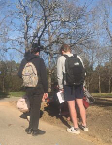
This activity, which involves spreading cereals (Froot Loops, Cheerios, and Cocoa Puffs) around Pullen Park, has students divided into two groups of search related patterns: intensive and extensive. The students in the individual groups then come up with a plan on finding these sites and how to record them using measuring tapes and points of reference. I came along for the survey and saw first hand these students work around different problems archaeologists face when it comes to discovering new sites and recording them. Problems like where to look and how to look were noticeable as each team employed different search tactics that aligned with their respective groups. The intensive group at first worked side by side looking along pathways and “rivers”. They eventually split up and continued the slow, step by step, walk to find more sites. Whereas the extensive groups were wanderers and maintained that spread for the hour I was there. One of the biggest advantages to this activity was that it forces students to be able to work within time constraints while getting as much data as possible. The more serious they took their search, the better the results they would get. This mimics the process of archaeological survey where there is a goal to attain and only so much time to attain it. By collecting this data, the students should be able to picture the spread on a map and hopefully synthesize the data to match the different time frames of the different settlements.
In my interview with her I asked a few main questions that I felt would amplify my own understanding of the activity and the base premise of the entire production.
What is the main motivator behind this activity? In other words, what do you hope students get out of this activity?
I have a couple of goals in doing this survey. The first goal is to get students used to gathering their own data, and then analyzing that data and using it to answer big picture questions. My second goal is to get them used to the “messiness” of data. They have to figure out how to pull out patterns from data that has been heavily impacted by natural and cultural processes.
What are the typical outcomes of this activity? Are there any noticeable patterns between what the intensive and extensive groups find?
In general, it works out as you would expect: the extensive teams are a little better able to see the whole settlement pattern across the park, and the intensive teams have a better idea of the details of settlement patterns in a smaller area.
In the greater scope of being an archaeologist, how does this activity compare to being in the field and excavating sites.
This activity really incorporates a lot of the things that archaeologists have to deal with when doing surveys. First, it incorporates the idea that some artifacts are more “visible” than others. For example, Froot Loops are easier to see than Cocoa Puffs, which means that they will be over-represented, relative to Cocoa Puffs, in the students’ results. Second, the students have to deal with terrain, weather and vegetation, all of which impact artifact visibility and therefore their results. Finally, they have to quickly figure out how to work in a team, share their results and use that shared data to complete an assignment. This kind of large team collaboration is also a feature of most archaeological work (both survey and excavation).
There were several different periods of settlement and development presented in this activity. Do you believe that the visualization of these different patterns help the students differentiate when dealing with real world scenarios?
These patterns are certainly the kind of patterns that students might find in the field, but of course on a much smaller scale. The “urban centers” of the Froot Loop phase, for example, are about 6 feet in diameter!
Having been out in the field with Grossman before, I can say for certain that there are so many different levels of intricacies when it comes to archaeological field work. Using GIS to map out potential sites, the best methods for actual excavation, the collection and analysis of data presented at these sites, and overall how to work as a team. The teamwork aspect of archaeology is crucial in any production, and this activity required people to work with others and try to really engage with the meaning of this lesson. This entire activity encompassed the basic levels of these challenges and for an introductory class provides a different perspective with the materials that are being learned. Hands-on engagement provides students with the necessary tools to refigure how they picture archaeology.
Thank you, Dr. Grossman for bringing me along and for enlightening me on your production of the cereal survey!
This article is by Olivia Fiser, a Department of Sociology and Anthropology student ambassador majoring in anthropology.